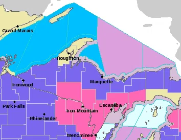
Including the cities of Iron River, Iron Mountain, Menominee, Escanaba, Gladstone, and Manistique
…WINTER STORM WARNING IN EFFECT FROM 4 AM EST /3 AM CST/ TO 7 PM EST /6 PM CST/ THURSDAY…
* WHAT…Snow expected. Total snow accumulations of 6 to 8 inches.
* WHERE…Iron, Dickinson, Menominee, Delta and Southern Schoolcraft Counties.
* WHEN…From 4 AM EST /3 AM CST/ to 7 PM EST /6 PM CST/ Thursday.
* IMPACTS…Plan on slippery road conditions. The hazardous conditions will impact the Thursday morning and evening commutes. If you must travel, keep an extra flashlight, food, and water in your vehicle in case of an emergency.
Including the cities of Gwinn and Marquette
…WINTER WEATHER ADVISORY IN EFFECT FROM 6 AM TO 10 PM EST THURSDAY…
* WHAT…Snow expected. Total snow accumulations of 3 to 6 inches.
* WHERE…Marquette County.
* WHEN…From 6 AM to 10 PM EST Thursday.
* IMPACTS…Plan on slippery road conditions. The hazardous conditions could impact the Thursday morning commute and will impact the Thursday evening commute. Slow down and use caution while traveling.
Including the cities of Grand Marais, Munising, Newberry, and Seney
…WINTER WEATHER ADVISORY REMAINS IN EFFECT UNTIL 10 PM EST THIS EVENING…
…WINTER WEATHER ADVISORY IN EFFECT FROM 6 AM TO 10 PM EST THURSDAY…
* WHAT…Light lake effect snow continuing this evening east of Melstrand and north of M-28 with additional snow accumulations of 2 to 4 inches. Then, snow expected tomorrow with new snow accumulations of 3 to 6 inches across the advisory area.
* WHERE…Alger, Luce and Northern Schoolcraft Counties.
* WHEN…For the first Winter Weather Advisory, until 10 PM EST this evening. For the second Winter Weather Advisory, from 6 AM to 10 PM EST Thursday.
* IMPACTS…Travel could be very difficult. The hazardous conditions could impact the Thursday morning commute and will impact the Thursday evening commute.